Digging Up the Past – Evington

BRONZE AGE, ROMAN AND SAXON EVINGTON
Any attempt to explore the archaeology of a heavily built up area such as Evington is hazardous because we must rely on chance discoveries in gardens and on building sites rather than systematically seeking evidence on ploughed farmland. Consequently there are bound to be gaps and distortions in our story.
The ancient parish covered an area from Mere Road in the west to Thurnby Brook in the east, Uppingham Road in the north and Gartree Road in the south. As yet no trace of man’s earliest existance has been found in this area but in the 19th Century flint tools including a barbed arrowhead and ‘thumbnail’ scrapers were discovered in the Spinney Hill district indicating a settlement of Early Bronze Age (about 4,000 years ago).
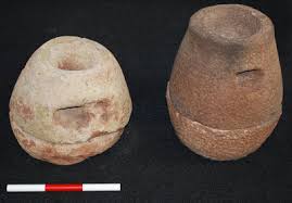
Further evidence dating back about 2,000 years was discovered in the Roman Road area in the 1930s but like many ‘chance finds’, it is tantalising in that only one object – a ‘beehive quern’ corn grinding stone – was kept from the site. A vague description of other finds, bronze strips and various stones, would suggest some sort of settlement. Near to this site ran the important Roman road to Colchester, Gartree Road, which was probably built as a supply route by the Roman army soon after the invasion of Britain in 43AD.
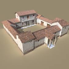
The most prestigious Roman site seems to have stood on Crown Hills since Roman material was found when the houses were being built and, more recently, pottery, tiles and ‘tesserae’ (stones from mosaic pavements) have been found on the allotments and in the gardens on Broad Avenue. These finds suggest the site of a Roman villa – the typical establishment of a wealthy landowner. It is interesting to note that whilst Medieval Evington Village was tucked awkwardly into the corner of this parish, the villa stands boldly in the centre, thus suggesting that the parish may owe its origins to the villa-estate. Other Roman finds include pottery from Blundell Road and near St Denys Church and coins from Rowlatts Hill which may indicate peasant farmsteads dependent upon the villa.
After the disappearance of the villa about 400AD there is another gap in the evidence until the late Saxon period when we know for certain a settlement existed in the area of St. Denys Church but if the parish is really a continuation of the villa-estate there was undoubtedly a settlement in the intervening years also.
From the period after the Norman Conquest, many more written records have survived which tell us the names of individual villages and give us a greater insight into their lives.
MEDIEVAL EVINGTON
The only surviving Medieval building within Evington Parish is St. Denys Church which has parts dating back to the 13th Century, although records show that a 12th Century church was given by the two lords of the manor, Ernald de Bosco and Jordan de Humet, to the Abbey of Leicester. Before this, Biddleston Abbey had rights to the church in the area suggesting an 11th Century establishment and there may even have been a church on the site as early as the 10th Century when estate churches began to proliferate.
It is no coincidence that the church stands next to the other major Medieval complex in the parish. Now known as Piggy’s Hollow, this is the site of a manor house, dating from the 13th or 14th Century but probably built on the same site as a late Saxon manor house alongside which the lord would have built his church. No buildings survive but earthworks include the moat surrounding the house, a fine series of fishponds and a large dam probably indicating a watermill, all possibly built by the de Grey family (of Codmore, Derbyshire not the Greys of Groby) who succeeded the de Humets as lords of the manor. A description of their property, dated 1308 when Henry de Grey died, mentions all these features.
Much time and effort was put into moat building, possibly for both status and defence, especially in view of the unsettled times of the late 13th and early 14th centuries. Robbery and murder were rife, with the Folville family of Ashby Folville being the county’s most notorious outlaws and even in Evington, murder was not unknown. A dispute began between Lucy de Grey and the Abbot of Leicester over a piece of land and a water course. This was probably the Evington brook which the Abbey, who owned the neighbouring parish of Stoughton, may have been damming for fishponds and thus affecting the watermill at Evington.
Four Evingtonians sent to Leicester on business by Lucy were attacked by men from the Abbey and one was killed.
The de Greys also owned a deer park, now totally built upon but which it is easy to locate from old maps giving field names such as Far Park Meadow, Highway Park and Park Leys Close. It corresponds roughly to the area bound by Evington Lane, the Brook and Stoughton Drive. This exclusive hunting preserve was a great status symbol but also a sound economic prospect for the meat and wood produced. Illegal hunting was prevalent and offenders included a member of the Hotoft family – lords of Humberstone.
A second, much larger moat, sited by the brook between Gwendolen road and Blanklyn Avenue, has long been built over but surviving records show it to be one of the largest in the county. The builders are unknown but were most probably the de Evingtons, a peasant family who accumulated a great deal of land during the 13th Century, both from the de Greys and from a smaller manor in the parish. The great size of the moat was therefore probably a statement by a socially inferior but increasingly wealthy family.
The names of other peasant cultivators, less wealthy than the de Evington, are known but relatively little has been discovered about how the land was worked. Open field agriculture was certainly practised and there are hints that animal husbandry was quite important. The names of the great fields are not known but much was enclosed by 1637 when the first-known map of the parish was drawn.
Much remains to be discovered about early Evington and many of the present conclusions are speculative but it is hoped that study of a fine collection of documents kept by Nottingham University will provide some clues to the development of the village.
Peter Liddle. Peter wrote these articles for the Evington Echo in 1982.
Peter Liddle will be coming to speak at Evington’s History and Heritage group on Thursday 19th February at 7.00pm in Evington Park House.

